Sri Lanka Project
Heavy mineral sand concentrations occur along the modern sandy shorelines of Sri Lanka in a number of places along the north eastern and north western coasts. The heavy minerals have been transported to the coast by river systems from ancient metamorphic rocks that form the hilly interior of the island. The heavy minerals have been locally concentrated by river transport, wind and coastal transport processes. Throughout the last few million years of geological evolution of the Sri Lankan coastal plains and coasts the heavy minerals have been subjected to many cycles of erosion, concentration and re-deposition. As a result of this extensive reworking and removal of lighter sand components, locally high grade heavy mineral sand deposits are present in unconsolidated modern ( 8,000 years old to present day) sands close to or on the coast.
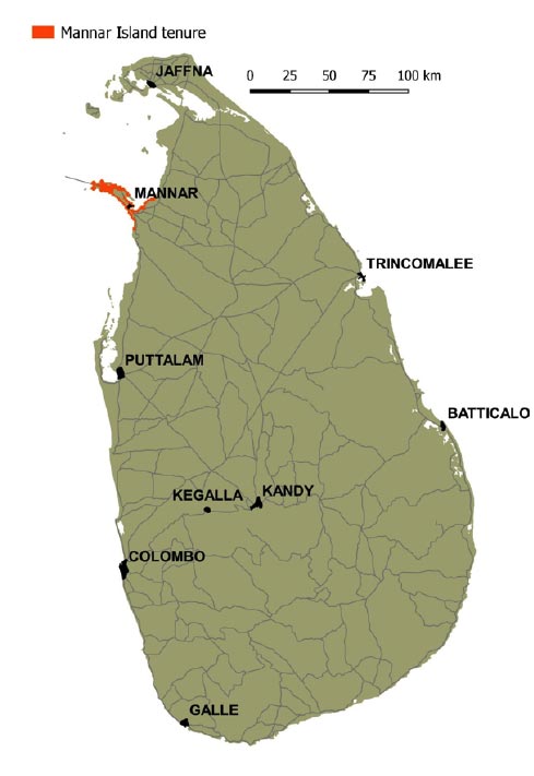
Titanium Sands Ltd holds five exploration licences a for heavy mineral sands located in North West Sri Lanka on Mannar Island and the adjacent mainland coast.
Exploration is currently been focussed around Mannar Island, an island 26 kilometers long and 6 kilometers wide and 140 square kilometres in area (Figure 2) joined to the mainland shore by road and rail connections over a short causeway. Mannar Island is the largest of a chain of sand islands and shoals that extend over 100 kilometers west to southern India in a broad arc (Figure 2) referred to as Adam’s Bridge or Rama’s Bridge depending on which ancient legend of its formation is being referred to.
Mannar Island in its present day form is geologically young feature that has been formed by sand accumulation since rising global sea levels began to stabilize around 6,000 – 8,000 years ago. Driven by the prevailing nearshore current and general circulation in Palk Straight nett sediment transport along the north west coast of Sri Lanka has been northwards until it has been captured by the evolving sand complex of Mannar Island (Figures 3, 4,5) and its adjacent sand spits and submarine banks. This process has tended to concentrate heavy mineral sands in the evolving beaches and coastal dunes of Mannar Island, with lighter carbonate and silica sands being winnowed out and transported west into the chain of sand bars and banks extending out across Palk Straight.
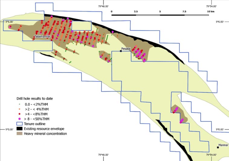
Hand auger drilling in 2010 and then in 2014, prior to Titanium Sands involvement, demonstrated significant high grade concentrations of heavy minerals along the northern and southeaster portions of the Mannar coast (Figures 6 and 7). Drilling at this time was largely restricted to within 150m inland of the modern beach. This was sufficient for an initial JORC standard resource (Table 1) to be reported after the project was secured under option by Titanium Sands Ltd (then Windimurra Vanadium Ltd).
*An initial JORC inferred mineral resource of 10.3 Mt with total heavy mineral (THM) of 11.7% was reported in full to the Australian Securities Exchange on the 22 April 2015.This resource was based on an historical drill hole data base of 785 auger drill holes and from the 115 holes drilled in early 2015. The drilling and the defined resource envelope were largely confined to within 150m of the Mannar Island shoreline. The Company confirms that this resource statement remains current in regards to the areas covered by the drilling used in the resource model.
Subsequent hand auger drilling in 2016 and 2017 (Figures 6 and 7) has demonstrated that significant heavy mineral concentrations occur in large areas of the Mannar Island interior. Samples from the 2016 and 2017 drilling have been analysed in a specialist mineral sands laboratory in South Africa. Results from this drilling were reported to the ASX on the 30th of January 2018.Mineralogical analyses of the heavy mineral species are being undertaken and a revision of the Mannar Island heavy mineral resources will be undertaken in due course.
SRI LANKA OVERVIEW
The island nation of Sri Lanka is situated close to the south eastern tip of the Indian subcontinent. For over three millennia Sri Lanka has been centrally located on major trade and migration routes. International trade and engagement have been an integral part of the nation’s history and remain so today in the rapidly evolving economic environment of Asia. Sri Lanka is only one of two South Asian nations to be ranked as high on the Human Development Index (HDI), an index that is a composite statistic of life expectancy, education, and per capita income.
Since independence from Britain in 1948 Sri Lanka has been a robust multiparty democracy with a high level of voter participation. A protracted civil war waxed and waned between 1982 and 2009. Although the war had roots in long running tensions between the majority Sinhala and minority Tamil populations it was more driven by radical minority political movements that centred around establishment of a separate Tamil homeland in the north of the country. Throughout the civil war government continued as a multiparty democracy that included representation and active participation from all of Sri Lanka’s ethnic and religious groupings.
The civil war period hampered development and inbound investment, particularly in the north of the country. However since 2009 the economy has shown rapid and consistent growth. Average annual GDP growth for five years until 2015 was 6.8%. Inbound tourism has increased from under 0.5 million in 2009 to 1.7 million in 2015. The Sri Lankan government is proactive in seeking international investment in most sectors of the economy with a range of incentives that include bilateral investment protection agreements with 28 countries, double taxation avoidance agreements with 42 countries, low corporate taxes, exchange control free capital and earnings repatriation, and duty free imports of plant and equipment. With a GDP of US$82 billion, total exports from Sri Lanka in 2015 were US$10.5 billion, with the United States and the European Union the largest importers. Exports from Sri Lanka are dominated by textiles, tea and rubber products.
Mining and quarrying is currently only a minor component of the Sri Lankan economy, contributing 2.9% of the GDP but only 0.5% or $52 million of export earnings. Mineral resources of Sri Lanka include gemstones, graphite, mineral sands and phosphate. The Government is keen to attract investment into the mining sector and to improve the profitability of several state owned mining companies. While foreign investment in resources projects is limited initially to 40% approval for higher levels can be sought from the Sri Lankan Board of Investment.
Currently the only significant reported heavy mineral sand production is by the state owned enterprise Lanka Sands Ltd from high grade coastal deposits on the north east coast near Trincomalee. The Lanka Sands operation has a production capacity of around 100,000 tonnes of heavy mineral concentrates but reportedly is operating at about half that capacity. The international mineral sand miner Iluka Ltd has a large resource on the mid west coast around Puttalam. The Iluka resource is 689 million tonne with 8.2% total heavy minerals. Ilmenite is the dominant heavy mineral, comprising 67% of the heavy mineral suite, equivalent to an in situ ilmenite grade of 5.5% ilmenite and minor amounts of zircon, 4% of the heavy mineral assemblage or 0.3% in situ grade. Iluka completed a scoping study in 2015, and indicated it was undertaking a prefeasibility study in 2016.


